
See what's |
Image 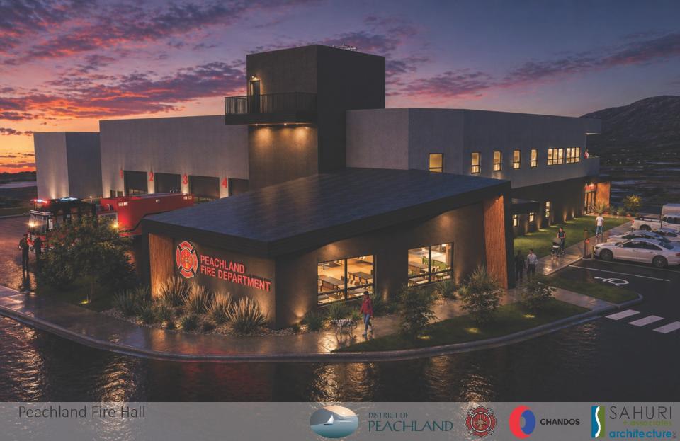 |
2026 Capital Projects
June 10, 2026
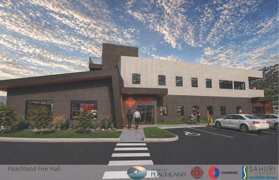
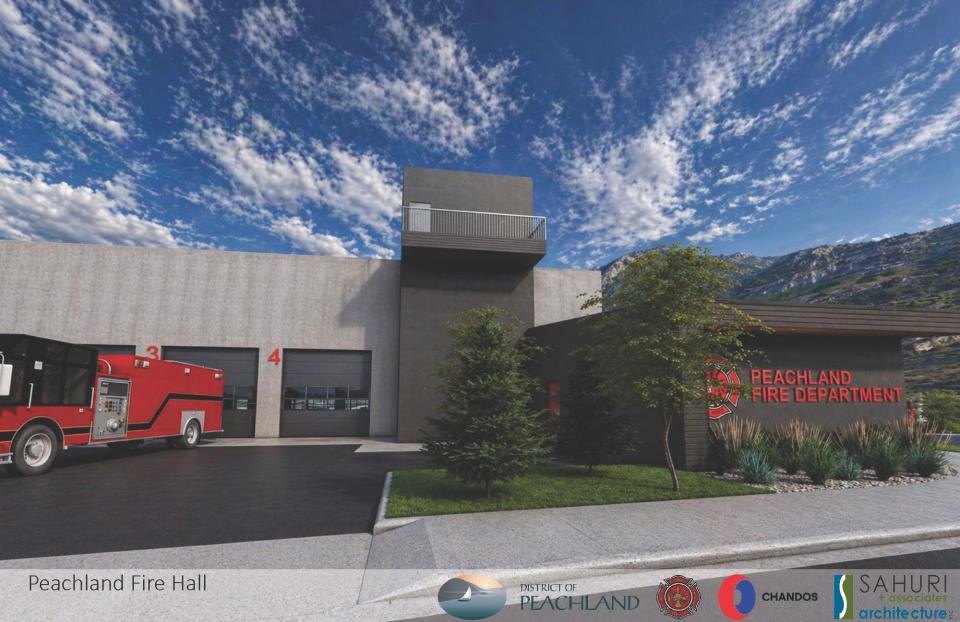
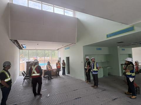
The District has awarded a design and construction contract for the new Peachland Firehall and a groundbreaking will take place soon.
After a successful Request for Purchase (RFP) process, Peachland Council has awarded the design-build contract to Chandos Construction LP, working in partnership with Sahuri + Associates Architecture.
“This long-awaited facility is one of the Council’s top priorities and represents a significant investment in public safety and emergency preparedness for our community,” said Mayor Van Minsel. “This is a major milestone for Peachland, and we look forward to seeing construction begin soon.”
The new 17,000-square-foot fire hall will be built on the land assembled for the new firehall at 4223 San Clemente Avenue adjacent to 13th Street, an important entrance to the community from Highway 97. The new building will feature four double apparatus bays with room for eight apparatus, dedicated space for community policing, and a rescue training tower to support firefighter training and development. The facility will also be built to meet modern National Fire Protection Association standards, ensuring Peachland firefighters have the tools and facilities they need to serve our community safely and effectively.
The project is well positioned to be delivered under the approved maximum budget of $17.5 million including land purchases, all past and future consulting and design services, and all construction. Detailed design of the new firehall will start immediately, with final building permit approvals anticipated for January 2027. While the project designs and permitting are in progress, the demolition of the existing building is anticipated for August 2026. The new Peachland Firehall is expected to be operational no later than December 31, 2028.
Members of the design-build team have completed a combined 30 firehalls or public safety buildings. Further to this, Chandos Construction recently completed the successful West Kelowna Firehall #32 (August 2025).
The RFP process undertaken in late 2025 was successful because:
A “Progressive Design-Build” RFP approach was undertaken,
Pre-engineered materials were encouraged, and
Current market conditions are favourable.
Construction on budget and ahead of schedule
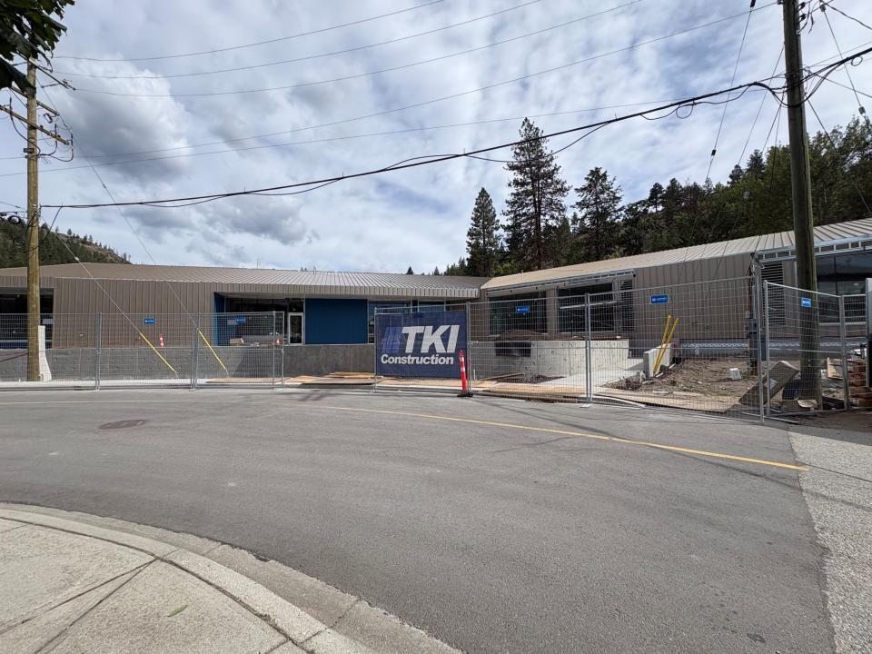
July 2026 - Construction of the new 106-space Peachland BGCO Childcare Centre at 5601 Wild Goose Street is ahead of schedule and is expected to be complete before the end of 2026. The roject is also on budget and, barring any unforeseen circumstances in the next 5 months, expected to be slightly under budget when complete.
Interior finishes including painting, millwork, and lighting plumbing fixtures are underway. On the exterior, the landscaping includes natural grass and wood play areas, water play stations, play structures, rubberized surfacing and plantings.
The Centre is being built on district-owned land on this new road created as part of this development. The District is partnering with the Okanagan Boys and Girls Club (BGC) as the non-profit operator of the new centre. HMC Architecture & Design completed architectural and engineering services and TKI Construction is overseeing construction management.
In August 2024, Peachland was given the wonderful news that it received $12.2 million in funding through ChildCareBC's New Spaces Fund to design, build and equip a new 106-space childcare centre adjacent to the Peachland Elementary School.
The Province of BC has begun construction to improve three Highway 97 intersections in Peachland with work on Buchanan Road South to continue until the winter shutdown period expected in December.
Part of promised safety improvements to the corridor, the Ministry of Transportation and Transit is improving the Highway 97 intersections with Trepanier Bench Road, Buchanan Road South and Buchanan Road North. The tentative schedule is as follows:
| Activity | Planned Start | Planned Completion |
| Mobilization and site set up | September 24, 2025 | September 30, 2025 |
| Segment B (Buchanan South) | October 1, 2025 | March 27, 2026 |
| Winter Shutdown (weather dependent) | December 2025 | March 2, 2026 |
| Segment A (Trepanier) | March 30, 2026 | May 18, 2026 |
| Segment C (Buchanan North) | May 19, 2026 | May 28, 2026 |
| Project Completion | End of May |
Trepanier Bench Road Intersection - Trepanier Bench Road will become the main point of access to the highway. A new traffic signal will be installed at the Trepanier Bench Road-Highway 97 intersection. As part of this improvement, access to the highway from Desert Pines Avenue will be limited to right-turn exits only. Left turns from Trepanier Bench Road to Desert Pines Avenue will no longer be permitted. The change is expected to limit delays for highway traffic caused by motorists waiting to turn.
Buchanan Road South - Northbound and Southbound traffic on Highway 97 will be able to enter Buchanan Road South via a new left-turn lane. Access to Highway 97 from Buchanan Road South will be restricted. A concrete median island will be installed to deter drivers from attempting to make a left-turn out of Buchanan Road.
Buchanan Road North/Huston Road - The intersections of Buchanan North-Highway 97 and Huston Road-Highway 97 will be right-in, right-out only. No left turns across Highway 97 will be permitted from either road, nor will left turns from Highway 97 onto either road. A concrete median island up the middle of Highway 97 will be installed at the Buchanan Road North-Huston Road-Highway 97 intersection.
Occasional single lane alternating traffic through the construction zone is anticipated when utilities are installed across Highway 97. For more information, visit news.gov.bc.ca. Find Project No. 25258-0000.
Questions can be directed to the Southern Interior Regional Office of the Ministry of Transportation and Transit at 250-828-4220 or kamloops.regional.transportation@gov.bc.ca.
More information is available at the Province of BC’s webpage for the project.
The District is capitalizing on work at the intersection, to repave Trepanier Bench Road. It is one of the top priority roads identified in the District’s pavement management program. The project budget is $450,000.
Questions can be directed to operations@peachland.ca.
Construction began April 7 on two new pickleball courts in Peachland’s Lambly Park.
The new courts will be constructed next to the current pickleball courts which will be closed beginning for construction. The project is expected to be completed by Friday, June 19, with the potential for the courts to open sooner.
Superior Excavating has installed fencing and signage directing the public through Lambly Park, adjacent to Highway 97 and accessed from 14th Street. Access will be maintained to the multi-use pathway and the tennis courts which will remain open.
The new courts, budgetted at $200,000, are one of the key 2026 capital projects the District is undertaking. The District is selecting and installing sound attenuation panels to all the pickleball courts at Lambly Park to help minimize noise impacts to neighbouring property owners - an initiative supported by funds from the Peachland Pickleball Society.
Questions can be directed to operations@peachland.ca.
The District has received a grant for $25,000 from SPARC-BC towards the replacement of the existing elevator at the Historic Schoolhouse on Beach Avenue.
The safer, more user-friendly elevator will provide universal access to the entire building. OurSPACE has committed to providing $25,000 of their own funds toward the project which is estimated to cost approximately $100,000. The District will fund the remainder of the project through its General Capital Renewal Reserve.
Questions can be directed to operations@peachland.ca.
In late March/early April, the District will replace the wooden surface boards on the central high dive dock with commercial-grade composite panels. This will resolve the issue with degrading boards posing risk to users.
The project is budgeted at $65,000.
Past Projects
Grand Opening Celebration June 20
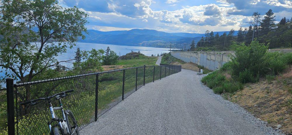
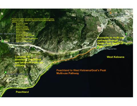
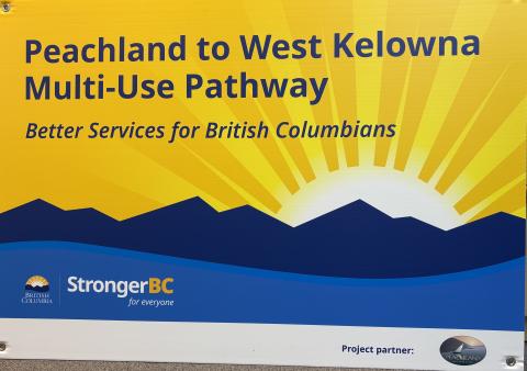
Peachland, B.C. – Peachland’s new Multi-Use Pathway to West Kelowna is complete! Cyclists and pedestrians now have a safe connection to Goat’s Peak Park, thanks to funding from the BC Ministry of Transportation and the Government of Canada’s Active Transportation Fund.
The trail is open to the public, with a grand opening celebration planned for Friday, June 20 at 10 am. Construction of the Peachland to Goat’s Peak Park Multi-Use Trail began in October 2024, funded with $776,000 from the BC Active Transportation Infrastructure Grants (BCAT) Program and $356,400 from the Federal Communities’ Active Transportation Fund of the Permanent Public Transit Program.
Park on Beach Avenue to access the trail via Buchanan Road and Robinson Place. The new constructed trail sections begin at Robinson Lane. It connects to Goat’s Peak Park near the Seclusion Bay Road underpass under Highway 97 near the boundary of Peachland and West Kelowna. It is made up of off-street multi-use pathways and a stretch of neighbourhood bikeway along Drought Road.
The trail ties into a planned 250km multi-purpose trail system that will span the Okanagan Valley. Three trail systems are close to connecting the communities from Sicamous in the North to Osoyoos in the south with the Shuswap North Okanagan Rail Trail, the Okanagan Rail Trail and The Trail of Okanagans. A fully connected trail system is expected to have a profound economic impact for the region and communities along the system and vault the trail system to one of international significance.
A Grand Opening Celebration will be held in the coming weeks; keep informed of upcoming events by subscribing to receive email notification from the District at www.peachland.ca/subscribe.
Peachland to West Kelowna Multi-Use Trail MAP - Trail of the Okanagans
News Release April 8, 2025
Peachland Receives Grant to Complete
New Westside Multi-Use Trail
Peachland cyclists and pedestrians will soon have a safe connection to Goat’s Peak in West Kelowna thanks to new funding from the BC Ministry of Transportation.
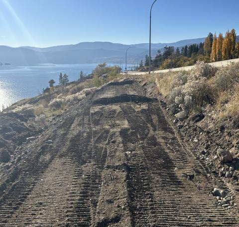
In early 2024, Peachland was awarded up to $420,236 through the BC Active Transportation Infrastructure Grants (BCAT) Program to build Phase I of a new 2.8 km multi-modal trail between Peachland and Goat’s Peak. This project also received a $356,400 grant from the Government of Canada’s Active Transportation Fund.
On March 31, while construction of Phase I is underway, the Province announced an additional BCAT grant of up to $500,000 for Phase II of the multi-use trail.
“We are so pleased the Province sees how important this project is for our community, and also the Government of Canada, through these active transportation grants,” said Mayor Patrick Van Minsel. “This is a very special project because it not only connects the two communities of Peachland and West Kelowna with a safe, multi-use pedestrian and cycling pathway, but it is also a critical link in the multi-use path networks that are connecting the communities from the North Okanagan to the South Okanagan.”
The Westside Multi-Use Trail will begin just north of the intersection of Highway 97 and Buchanan Road in Peachland and end near the Seclusion Bay Road underpass under Highway 97 near the boundary of Peachland and West Kelowna. It is made up of short sections of protected off-street multi-use pathway adjacent to Highway 97, off street multi-use pathways and a stretch of neighbourhood bikeway along Drought Road.
The Peachland to Goat’s Peak Multi-Use Trail will tie into a 250km multi-purpose trail system that will span the Okanagan Valley. Three trail systems are close to connecting the communities from Sicamous in the North to Osoyoos in the south with the Shuswap North Okanagan Rail Trail, the Okanagan Rail Trail and The Trail of Okanagans. A fully connected trail system is expected to have a profound economic impact for the region and communities along the system and vault the trail system to one of international significance.
BC Active Transportation and infrastructure grants provide cost-sharing opportunities for the development of active transportation infrastructure for all ages and abilities, aligning with the provincial strategy for cleaner, more active transportation to reduce carbon pollution and improve the health and wellbeing of BC residents.
The District has already received funding through the Government of Canada’s Active Transportation Fund. This grant will support up 60% of the total eligible costs (up to $356,400). Both funding streams can be accessed concurrently for this project and the District of Peachland has included its portion of the project cost in the current budget. The District has committed to up to $500,000 to the project.
Construction of the new multi-use pathway is expected to be complete by the end of May 2025. Watch for news of an official opening ceremony in the coming weeks. Stay informed by signing up to receive email notification from the District at www.peachland.ca/subscribe.
More information:

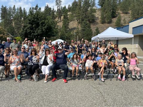
The Turner Park Upgrade project is complete. Improvements include new player benches and upgraded baseball dugouts, upgraded backstop, and upgraded park fencing along Turner Avenue. The new playing fields are complete. Council agreed to apply some of the Growing Communities Fund grant it received to upgrade the playing field.
- New set of viewing bleachers for the baseball diamond
- Removal of the old playground and replacement with new (see note on the design below)
- Connection of the washroom to the sanitary sewer system
- Accessibility improvements to the washroom building
- Removal of the sports box asphalt and fencing and replacement with grass
- Improvement of the parking area
- Irrigation installation
- Accessible pathway installations
- Public benches, waste receptacles and accessible picnic tables
- Vegetation and shade structure installations
The Turner Park Upgrade project is funded through a portion of the $2.7 million received in April from the Province’s Growing Communities Fund and a Jays Care Foundation grant. Turner Park is expected to be fully open, with the field ready for competitive soccer, in early September 2025.
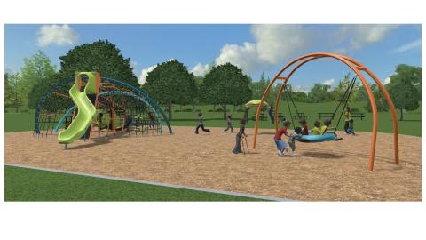
Coordinated by the District of Peachland, the students of Peachland Elementary took part in a DOT-MOCRACY, voting by using stickers, on three potential designs for the new playground in Turner Park. Students overwhelmingly voted in favour of one design in particular (pictured below). Council enthusiastically supported the students’ playground style choice at its meeting April 9.
Project Background
The land for Turner Park, located at 6114 Turner Avenue, was acquired by the District of Peachland on March 30, 2021. The 3.34 hectare (8.26 acre) property was formerly owned by School District #23 and is one of the only remaining undeveloped properties able to accommodate athletic fields and other park amenities requiring flat land. The District of Peachland is looking to dispose of the lower site of the property fronting Princeton Avenue, which leaves a balance of 2.25 hectares (5.5 acres) available for parkland. The Turner Park Concept Plan will build on the findings of the 2018 Parks and Recreation Master Plan and the 2020 Community Park Concept Plan: Sanderson, Heritage and Cousins Park to:
- Assess community needs and desires for park space and amenities;
- Identify the need for future amenities relative to use trends, population growth, and demographics;
- Assess feasibility for park development;
- Create concept drawings (30% working drawings); and
- Provide recommendations for implementation including cost projections, phasing and potential funding sources. Infrastructure updates that have been completed are;
Swim Bay Flood Mitigation 2023
The flood mitigation project at Swim Bay, begun in the spring and completed in late July, involved the installation of rip-rap, anchored logs, V-logs and rock groynes (a shore protection structure built perpendicular to the shoreline). The project aims to re-establish a more natural shoreline that historically broke waves. New landscaping and irrigation and re-decking of the T-dock was also completed. This flood mitigation project is grant-funded and will protect critical infrastructure including Beach Avenue, underground utilities, retaining walls, docks and accessibility ramps.
Find more information about asset management at Infrastructure Planning