
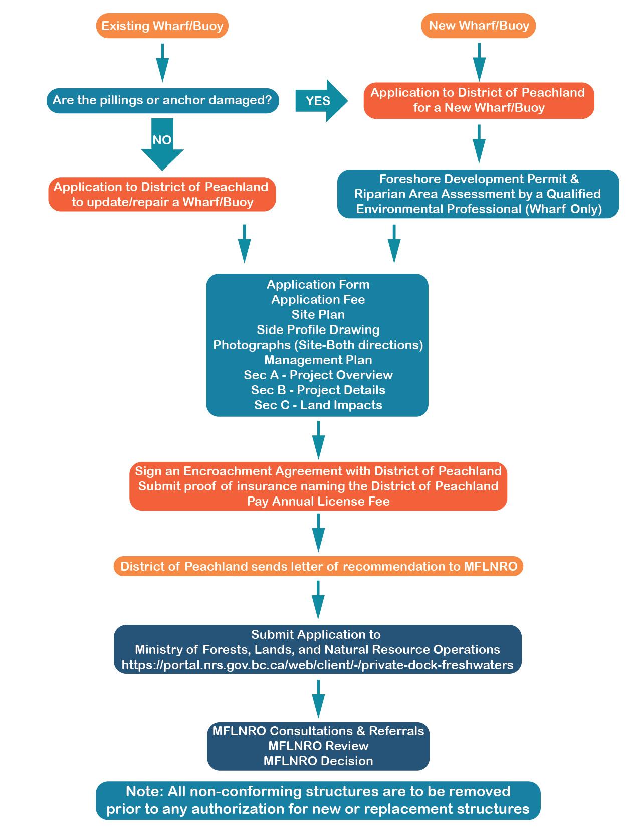
Even though the District holds a Head Lease over the foreshore area, certain Provincial and Federal legislation also applies.
Ministry of Forests, Lands, and Natural Resource Operations
Canadian Coast Guard
In 1982, the Corporation of the District of Peachland began the process of creating a strategy to guide the future use and development of the 11.25km shoreland fronting on Okanagan Lake, within the Municipality. The area was divided into 12 Units (see Shoreland Plan Map below) based on their location and the conditions in each area. Each of the 12 Units was evaluated and permitted uses were determined based on the natural and man-made features, natural shoreland processes, the goals and aspirations of local residents, property owners, the Municipal Council, and interested Provincial Government Ministries.
Shoreland Plan Map
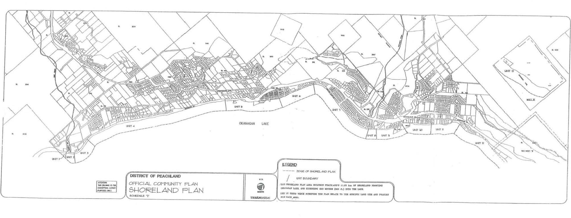
Unit 1
Location: From Antler's Beach to 75m South of Peachland Creek (Deep Creek)
Permitted Uses:
-No shoreland development
-No wharves or buoys
Unit 2
Location: From 75m South of Peachland Creek to 75m North of Peachland Creek (Deep Creek); Unit 2 is designated as a conservation area, 75 meters in each direction from the mouth of Peachland Creek
Permitted Uses:
-No wharves or buoys
Unit 3
Location: From 75m North of Peachland Creek to the North side of 6575 Highway 97 (former Red Lion site)
Permitted Uses:
-No foreshore development
-No wharves or buoys
-Recreational uses allowed: Boating, Personal Watercraft, Fishing, Water Skiing
Unit 4
Location: From the restaurant site located at 6575 Highway 97 to the South end of 'Doggie Beach' and the T-boat launch
Permitted Uses:
-No upland development
-No foreshore development
-No wharves or buoys
-Recreational uses allowed: Boating, Personal Watercraft, Fishing, Water Skiing
Unit 5
Location: From 'Doggie Beach' South of the T-boat launch to 4th Street
Permitted Uses:
-Public and Commercial recreational facilities
-Pets allowed in posted designated areas South of the T-boat launch
-Dog swimming to the left of the T-boat launch on the lakeside below Beach Avenue and Highway 97
-Day use wharf located between 1st and 2nd Streets
-Houseboat mooring between 2nd and 4th Streets in designated areas during daylight hours
Unit 6
Location: From 4th Street to 5606 Beach Avenue (Strachan's Corner)
Permitted Uses:
-'Swimming Only Area' from 5th street to the North end of Swim Bay
-Recreational uses allowed except in 'Swimming Only Area' include boating and swimming
-Limited seasonal commercial uses may be permitted
-Peachland Yacht Club
-Dogs allowed in the park along Beach Avenue (on leash) from the Cenotaph to Swim Bay
-Dog swimming area from 8th Street to 13th Street
Unit 7
Location: From 5606 Beach Avenue to 75m South of Trepanier Creek
Permitted Uses:
-Swimming from 5606 Beach Avenue to the North side of the 13th street picnic area
-Recreational uses allowed from North of the 13th street picnic area to 75m South of Trepanier Creek include boating, swimming, SUP
-Dogs allowed in the park along Beach Avenue (on leash) from Swim Bay to 13th Street and 13th Street view point
-Limited seasonal commercial uses may be permitted
Unit 8
Location: From 75m South of Trepanier Creek to 75 North of Trepanier Creek (3996 Beach Avenue - Lakeshore Gardens). Unit 8 is designated as a conservation area, 75 meters in each direction from the mouth of Trepanier Creek.
Permitted Uses:
-No wharves or buoys
Unit 9
Location: From 75m North of Trepanier Creek to 3902 Beach Avenue (Todd Beach)
Permitted Uses:
-Vehicle and boat trailer parking
-Recreational uses allowed except in 'Swimming Only Area' include swimming, boating, SUP
-No Use Zone designated within 15m of the Water System #1 Emergency intake
-Private swimming floats are permitted only in front of the private waterfront tourist facilities
Unit 10
Location: From 3902 Beach Avenue (Todd Beach) to 3701 Beach Avenue (Davis Cove Resort)
Permitted Uses:
-Private mooring buoys in existence prior to July 23, 2003 are permitted in this area
-No wharves permitted
-No new buoys permitted
-Recreational uses allowed include boating, swimming, personal watercraft, fishing, water skiing, SUP
-No swimming floats other than Municipal wharves are permitted in this Unit. Other private floats or structures are not permitted.
-No Use Zone designated within 15m of the Water System #1 Emergency intake
Unit 11
Location: From 3701 Beach Avenue to 5122 Buchanan Road
Permitted Uses:
-A public beach access along the right of way of Burdekin Lane. Dogs are allowed on leash.
-Each waterfront parcel may apply to have
- one dock/wharf that may be equipped with a boat lift (Max lift size 7.5m)
- one mooring buoy
-Strata units at Jackson Cove and Davis Cove are permitted separate buoys provided all buoys are within the site's frontage and within 30m of the shoreline *Specific Conditions Apply*
Unit 12
Location: From 5122 Buchanan Road to the Municipal boundary (South of Seclusion Bay Resort)
Permitted Uses:
-Each waterfront parcel may apply to have
- one dock/wharf that may be equipped with a boat lift (Max lift size 7.5m)
- one mooring buoy